Features
Road and traffic
Don't know Brayford? Watch the road/lane journey that serves the village and its residents. If you are involved with planning some time driving this road (and its alternative detour roads) may make it clear why so many residents are concerned.

What the megafarm would mean for the road through Brayford
If you live in Brayford, walk to the school, or drive up towards Holewater Hill then you're on Brayford's "main road". Here is what the applicant's own figures say about it, what they leave out, and why it matters.
The short version
-
There is only one road to the farm from the A399, and it runs through the middle of Brayford and past the school [3].
-
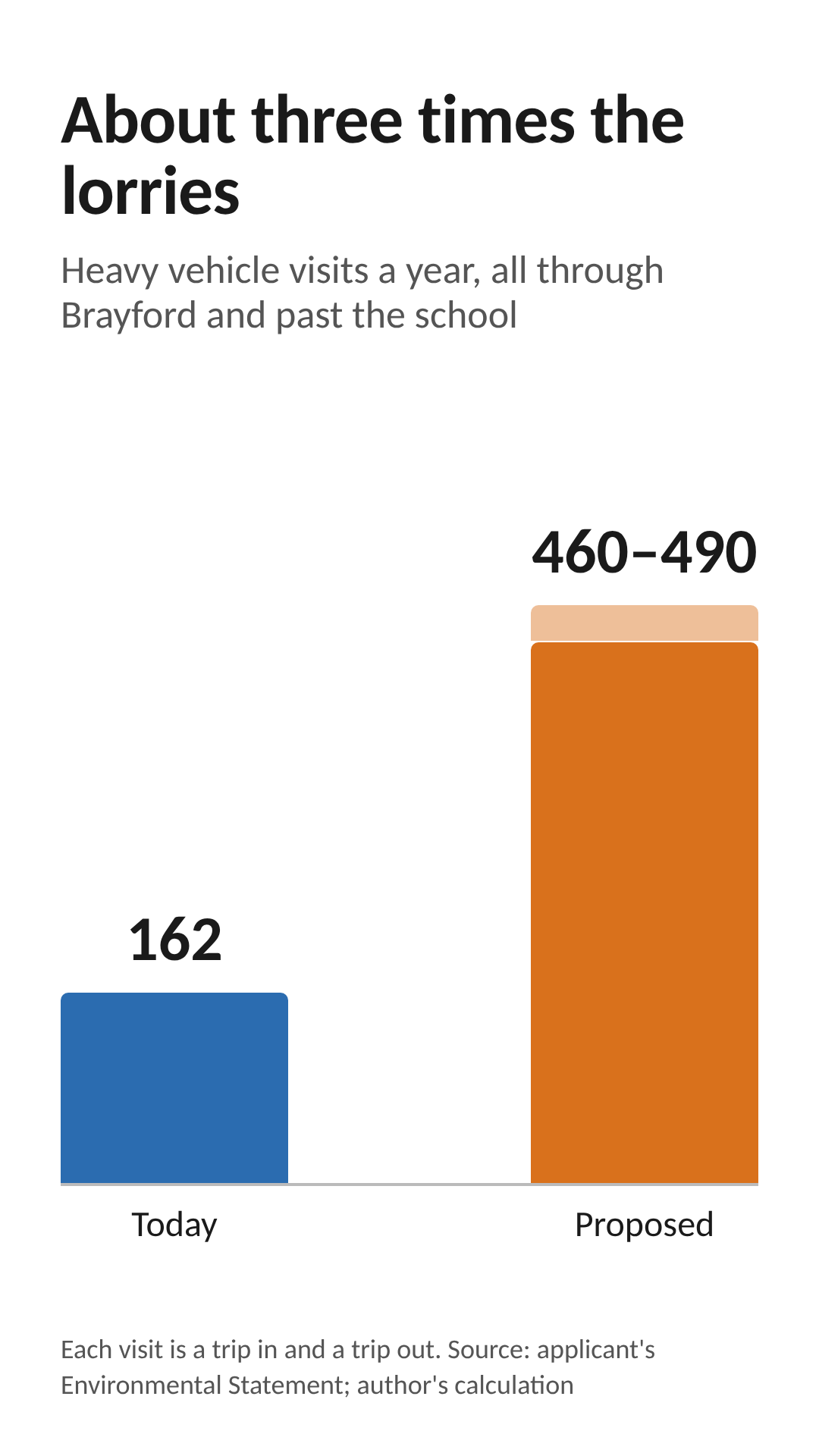
Heavy vehicle visits to the farm would roughly treble, from about 162 a year to about 460 to 490 [1].
-
The lorries would bunch up around the end of each crop, and bird collection often happens at night [5].
-
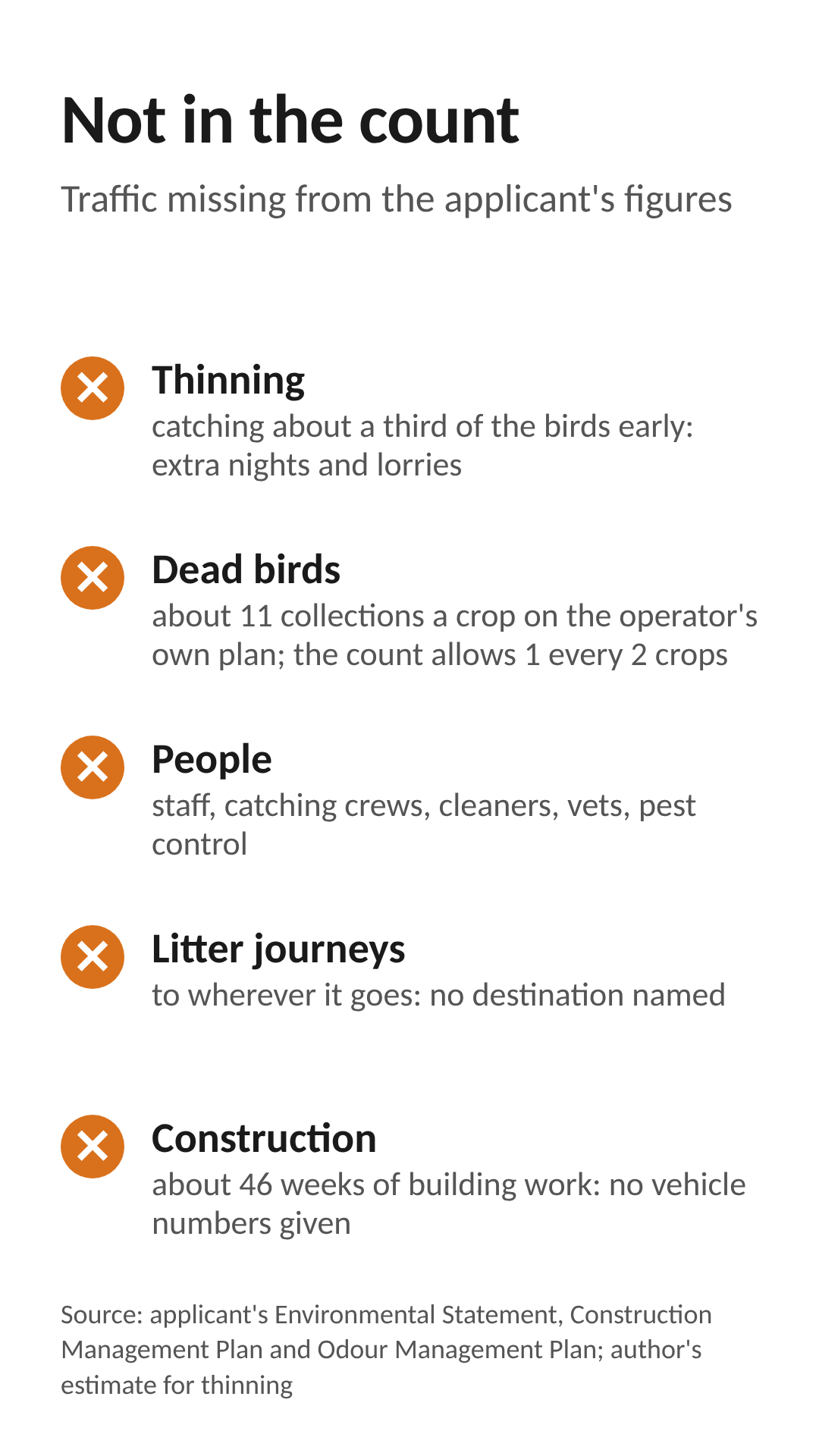
Several kinds of traffic are not counted at all.
-
The application looks only at the farm entrance, not at the road through the village [1].
One road in, one road out
Every vehicle going to or from the farm, whether it is a feed lorry, a chick delivery or a building contractor, has to come off the A399, through Brayford, past the school and up the hill. There is no other way in [3]. The applicant's own construction plan uses this route and accepts there is "likely to be an increase in traffic through the village of Brayford" [4].
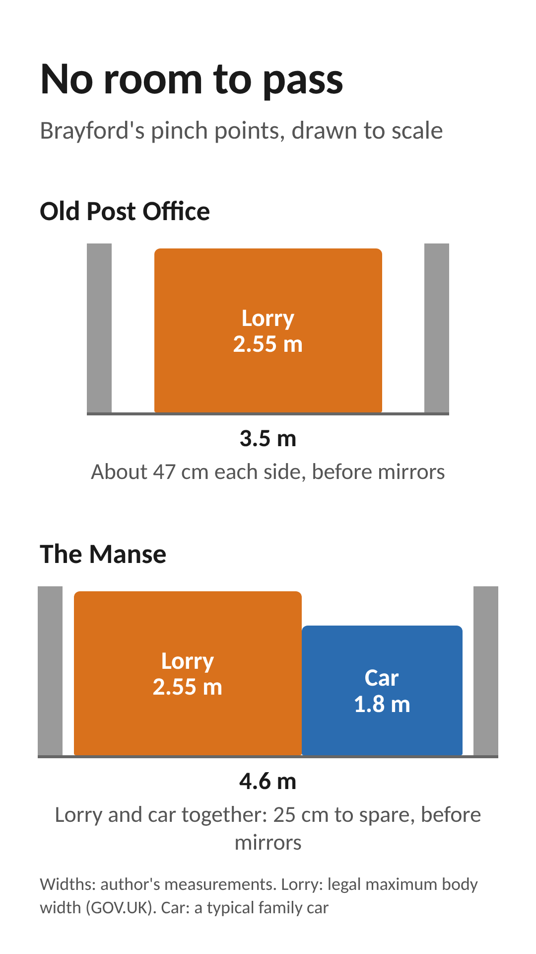
The road is narrow in places. The author has measured two pinch points: about 3.5 metres (11.5 feet) at the Old Post Office and about 4.6 metres (15 feet) at The Manse [3]. For comparison, the body of a large lorry can legally be up to 2.55 metres wide, before you count its mirrors [9]. At the Old Post Office, that leaves no room for anything coming the other way. Drivers already have to stop or reverse at these points to let each other through.
How many lorries?
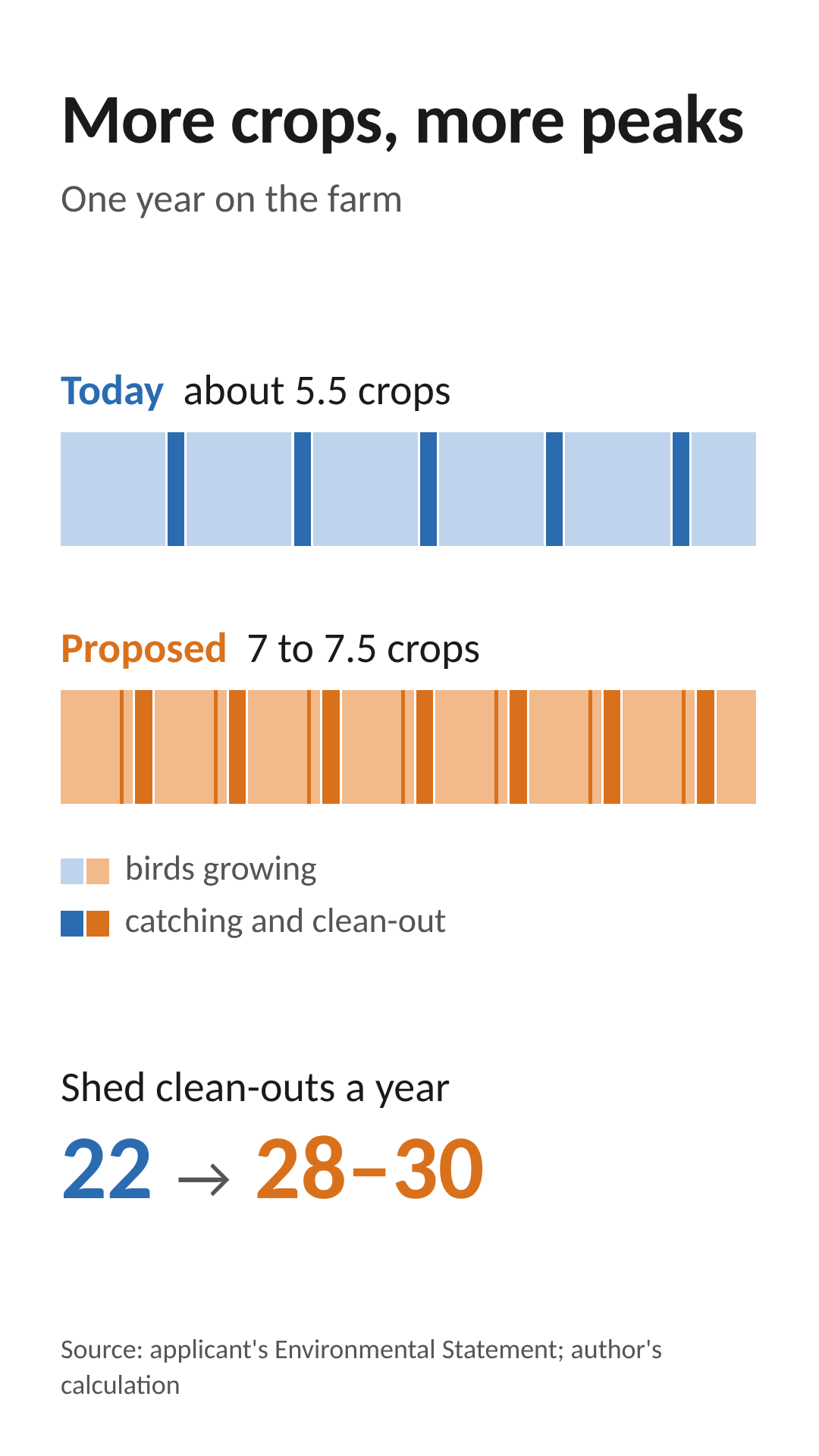
The applicant counts heavy vehicle visits for each crop of birds, meaning each batch of chicks from arrival to clean-out [1]. Today a crop takes 66 days; under the proposal it would take 49, so there would be more crops each year as well as more lorries per crop.
What the vehicle is for
Feed
Taking birds away
Manure (used litter)
Day-old chicks
Gas
Bedding
Dirty water
Dead birds
Total visits per crop
Crops per year
Total visits per year
Today (per crop)
7
6
11 tractor loads
1
1
2
1
1 every 2 crops
29.5
5.5
about 162
Proposed (per crop)
26
22
8 lorries
4
3
1
1
1 every 2 crops
65.5
7 to 7.5
about 460 to 490
Each visit is a trip in and a trip out, so that is roughly 920 to 980 heavy vehicle movements through the village a year, about three times today.
Source: the applicant's Environmental Statement [1]. The yearly totals are the author's calculation from the applicant's figures where the applicant does not give one.


"About one a day" is not what you'll see
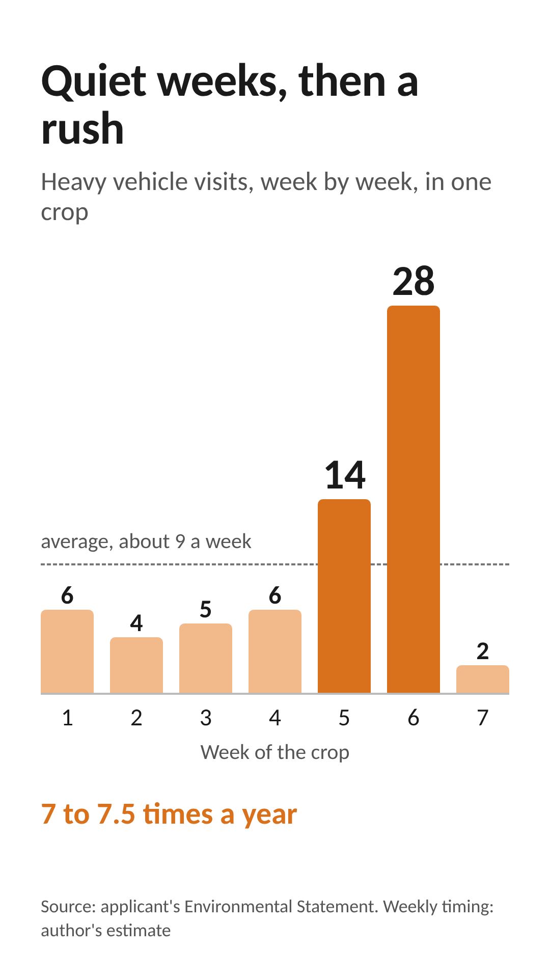
The Environmental Statement describes the traffic as "approximately 1 trip per day" [1]. That is an average, and it hides the pattern. A crop starts quietly, with chicks and bedding arriving. Feed lorries come more often as the birds grow. Then, at the end of each crop, the birds are collected, the sheds are cleared and the litter is taken away. About 31 of the 65.5 visits fall in that last week or two (author's calculation from the applicant's figures). The village would see bursts of heavy traffic seven or more times a year, not a steady trickle as "1 trip per day" implies.
The feed lorries alone carry up to about 28 tonnes each, and there would be about 180 to 195 of them a year [1].
Lorries at night
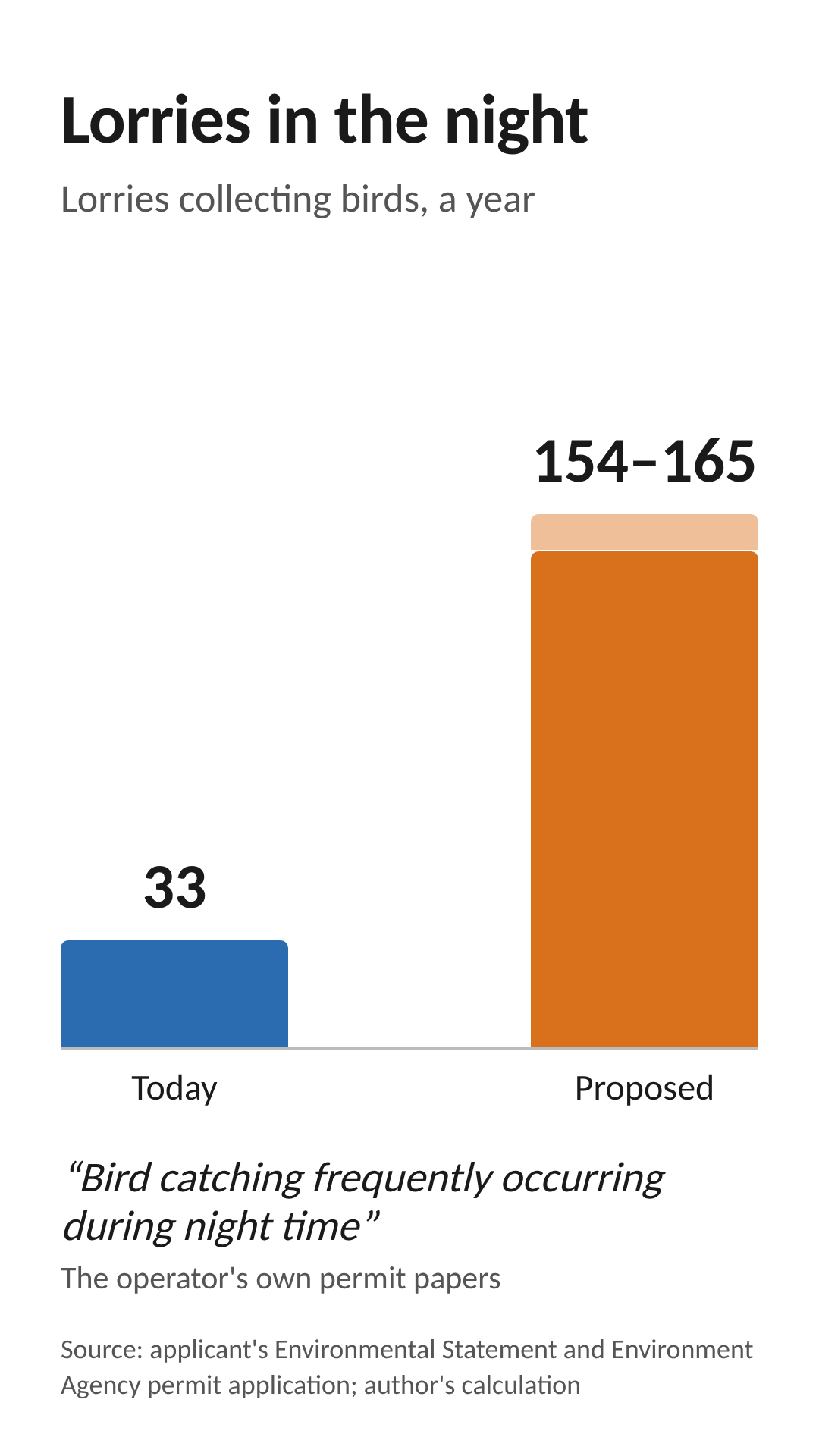
Chickens are usually caught in the dark, when they are calmer. The operator's own permit papers say bird catching is "frequently occurring during night time" [5]. With 22 bird lorries per crop, that is about 154 to 165 bird lorries a year, up from about 33 today (author's calculation), many of them at night and all through the village.
Nothing in the application limits when lorries can run. The operator's noise plan says delivery hours of 07:00 to 20:00 can be applied "if required" [7]. That is not a commitment.
What the figures leave out
-
Early collections. The sheds only work at the stocking density the applicant states if a share of the birds, roughly a third on the author's estimate, are caught and taken away early. This is called thinning. It means extra catching nights and possibly extra lorries, and it is not mentioned in the traffic figures. The only reference to it anywhere in the application is one line in the odour plan [6].
-
Dead birds. The traffic figures allow one dead-bird collection every two crops [1]. The operator's own odour plan describes "Twice weekly collection" [6], which would be about 11 collections while each crop is on site.
-
Staff and contractors. Staff, catching crews, cleaning contractors, vets and pest control. Staff are listed as a source of traffic but never counted [1].
-
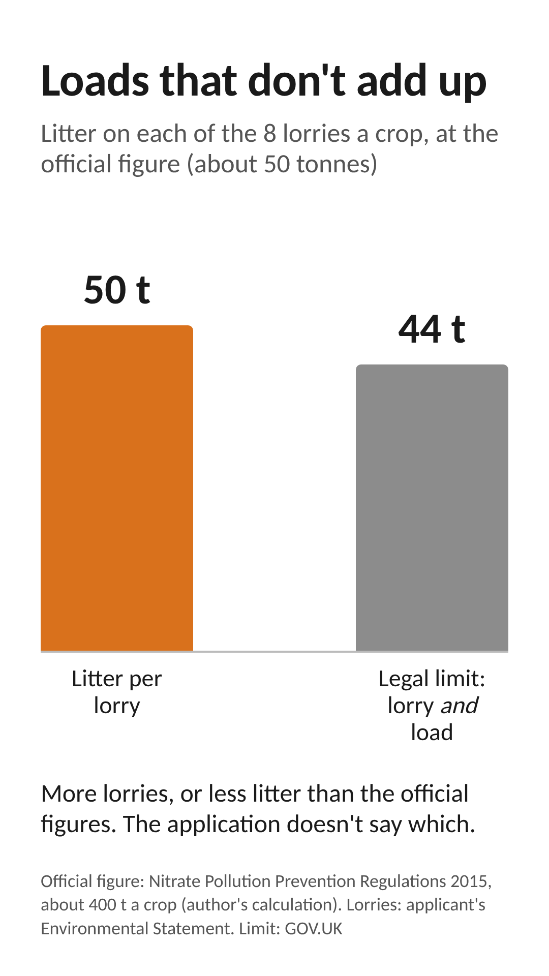
Litter. The application never says how much litter the farm would produce. On the government's official figures it would be far more than 8 lorries per crop could carry; each would need to take about 50 tonnes, above the 44-tonne legal limit for a fully loaded lorry [10][9]. Either more lorries are needed, or the figures are wrong. The journey to wherever the litter ends up is not assessed either.
-
Building work. Construction would take about 46 weeks, with about 66,800 tonnes of soil and rubble moved around the site, yet no construction vehicle numbers are given [1][4].
What has been assessed, and what has not
The applicant's traffic assessment looks at the farm entrance. It finds that drivers can see far enough in both directions, and concludes: "No further mitigation is therefore considered necessary." [1] (See below.) It also notes that there have been no recorded accidents on the local roads in the last ten years [2]. That is fair, and it reflects the road as it is used today.
What it does not look at is the road between the A399 and the farm: the widths, the pinch points, the bridge, where lorries can pass each other, or what happens when a lorry meets a car, a tractor, a horse or a child walking to school. Apart from a note in the construction plan about avoiding school start and finish times [4], the school is not considered at all.
There is also a proposed scheme of 14 homes near the farm, at consultation stage. On the author's count it would more than double the number of homes on this road, and add about 28 cars if each home has two (an assumption). Nobody has looked at the two schemes together.
When this was written, Devon County Council, as the highway authority, had been consulted on the application but had not yet replied [11].
Who can do something about it
The Environment Agency's permit covers what happens on the farm: odour, ammonia, dust and so on. It does not cover traffic [1]. Only North Devon Council can control lorries, through planning conditions or a legal agreement. That could include limits on lorry hours, no movements at school start and finish times, a cap on bird numbers and crops a year (which sets the number of lorries), and a proper assessment of the road before any decision.
National planning policy says development should be refused on highway grounds if it would have "an unacceptable impact on highway safety" [8]. Whether trebling the heavy traffic on this road meets that test is a question the application has not tried to answer.
Sources
[1] Environmental Statement, Acorus Rural Property Services, August 2026: chapter 15 (paragraphs 15.2 to 15.5), paragraph 5.1.2 and paragraph 21.1.3.
[2] Transport Statement (planning application 82141).
[3] Author's local knowledge and measurements using Google Earth.
[4] Construction Environmental Management Plan (App 8), Connops, 9 July 2026, revision 0.1, and Waste Audit Statement (planning application 82141).
[5] Noise and Vibration assessment, Environment Agency permit application, 24 July 2026.
[6] Odour Management Plan, Environment Agency permit application, 24 July 2026.
[7] Noise and Vibration Management Plan, Environment Agency permit application, 24 July 2026.
[8] National Planning Policy Framework (2026), policy TR6(4) (gov.uk).
[9] GOV.UK, vehicle weights and dimensions: 44 tonnes maximum gross weight; 2.55 metres maximum vehicle width.
[10] The Nitrate Pollution Prevention Regulations 2015, Schedule 1: meat chickens, 0.06 kg of manure including litter per bird per day (legislation.gov.uk).
[11] North Devon Council planning portal, application 82141: consultation dates and consultee list, checked 12 October 2026 (planning.northdevon.gov.uk/Planning/Display/82141).
Governing regulations
These are the key regulatory and highway considerations that apply to the proposed intensive broiler unit as the author has come to understand.
There's a focus on the clear separation of powers between the Environment Agency’s environmental permitting regime and the local planning system’s responsibility for assessing off-site traffic impacts.
1. Regulatory Split
The Environment Agency’s environmental permit controls only on-site emissions and operations (ammonia, odour, dust, litter, etc.) inside the farm boundary. It has no power over off-site traffic. Highway impacts fall exclusively to North Devon Council (as Local Planning Authority) and Devon County Council (as Highway Authority). These impacts can be controlled through planning conditions or a Section 106 agreement.
2. National Policy Test (NPPF)
Development can be refused on highway grounds only if it would cause an unacceptable impact on highway safety, or if the residual cumulative impacts on the road network (after mitigation) would be severe. On North Devon’s narrow rural lanes the safety test is usually decisive.
3. Local Policy
Policy DM05 of the North Devon and Torridge Local Plan requires safe vehicular access and egress and requires the Council to protect the needs of all road users, including pedestrians, cyclists and horse riders who share single-track roads.
4. Evidence Required
A formal Transport Assessment is expected. It must address:
-
Peak traffic during the final catching/clearing phase of each crop cycle
-
Swept-path analysis showing the largest HGVs can negotiate bends and junctions without mounting verges
-
Visibility splays based on measured road speeds
-
Cumulative effects with existing agricultural, quarry or forestry traffic
5. Conclusion
If the applicant fails to demonstrate that the additional HGV movements can be accommodated safely, Devon County Council Highways has the right to object as approval against an unresolved formal highway-safety objection would leave the Council vulnerable to legal challenge.